Application Description
If you're looking for a streamlined way to handle KML/KMZ/GPX files, GIS functionalities, measuring tools, GPS logging, WMS capabilities, and offline maps, then MAPinr is the app you need. As a non-profit project, we're committed to keeping pace with the rapid Android version updates to provide you with a secure, privacy-focused, and affordable app.
We understand that the latest Android versions, such as Android 14, may not be supported by all devices. That's why we offer downloads for older Android versions directly from our website, ensuring everyone can enjoy MAPinr's features.
Are you interested in managing your personal points of interest or placing your photos on a map? MAPinr is the perfect solution. Our ad-free Android app is designed for both professional and recreational use, catering to activities like hiking, cycling, running, skiing, and more.
We value your feedback and encourage you to share your thoughts and suggestions with us at [email protected]. We understand that encountering software bugs can be frustrating, but we appreciate your patience and understanding as our resources are limited. Your input is crucial for improving MAPinr.
MAPinr offers a comprehensive set of features:
- Ad-Free Experience: Enjoy an app without any intrusive ads.
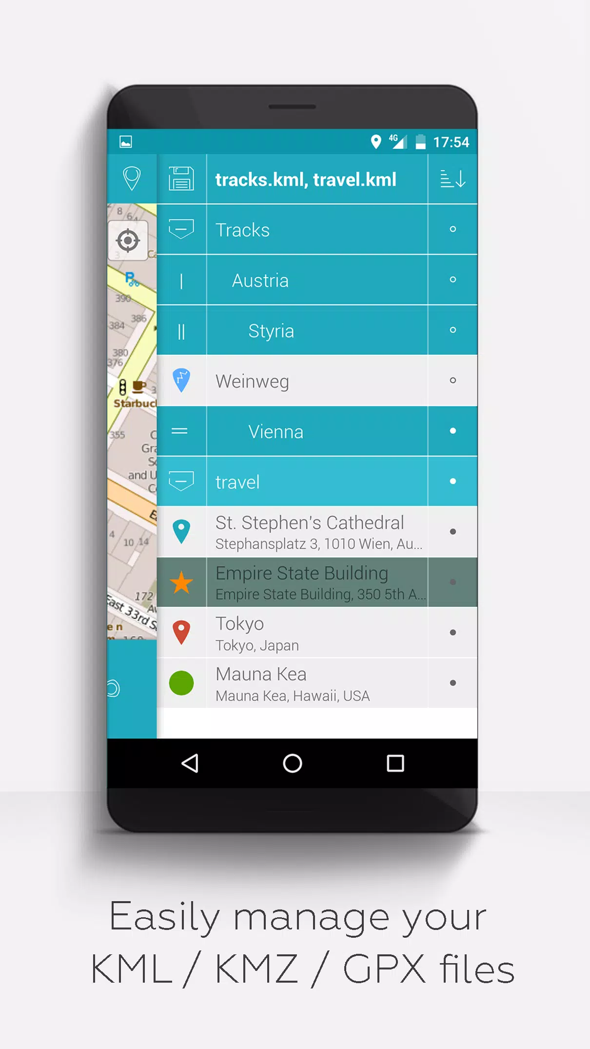
- Hierarchical Folder Structure: Easily manage multiple KML/KMZ/GPX files.
- Comprehensive File Management: Create, load, edit, save, import, export, and share KML/KMZ files.
- Waypoint, Line/Track, and Polygon Management: Create, load, edit, save, import, export, and share these elements.
- Photomaps: Add pictures to your waypoints to create personalized photomaps.
- Versatile Map Display: Show waypoints, lines/tracks, and polygons on various maps including Maps, Satellite, Hybrid, OpenStreetMap, Opentopomap, and Opencyclemap.
- Coordinate Sharing: Share waypoint coordinates with others.
- Customization: Individually colorize waypoints, lines/tracks, and polygons.
- Interoperability: Open exported KML/KMZ files in other apps.
- Search Capabilities: Search by name, address, and coordinates.
- Location Sharing: Share your location with friends.
- Multi-File Display: Display multiple KML/KMZ/GPX files simultaneously.
- File Merging: Merge KML/KMZ files as needed.
- Cloud Integration: Seamlessly integrate with cloud services.
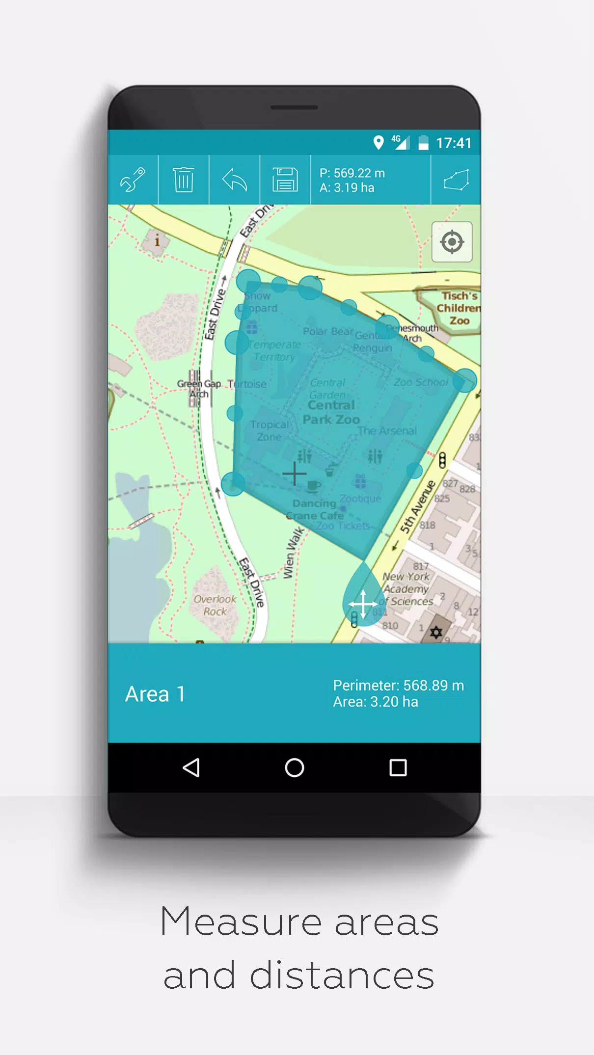
- Measurement Tools: Measure distances and areas directly on your map.
- Multilingual Support: Currently available in English, Spanish, Lithuanian, and Polish.
For those who wish to access extended features, you can do so for free with a donation or by liking us on LinkedIn. Activate these in the app's settings:
- Offline Maps: Download OpenStreetMap maps for offline use.
- GPX Viewer: Display GPX files.
- Web Map Service (WMS): Display custom map data from services like www.data.gov.
- Custom Metadata: Create and manage custom metadata.
- Custom Icons: Upload and use your own icons.
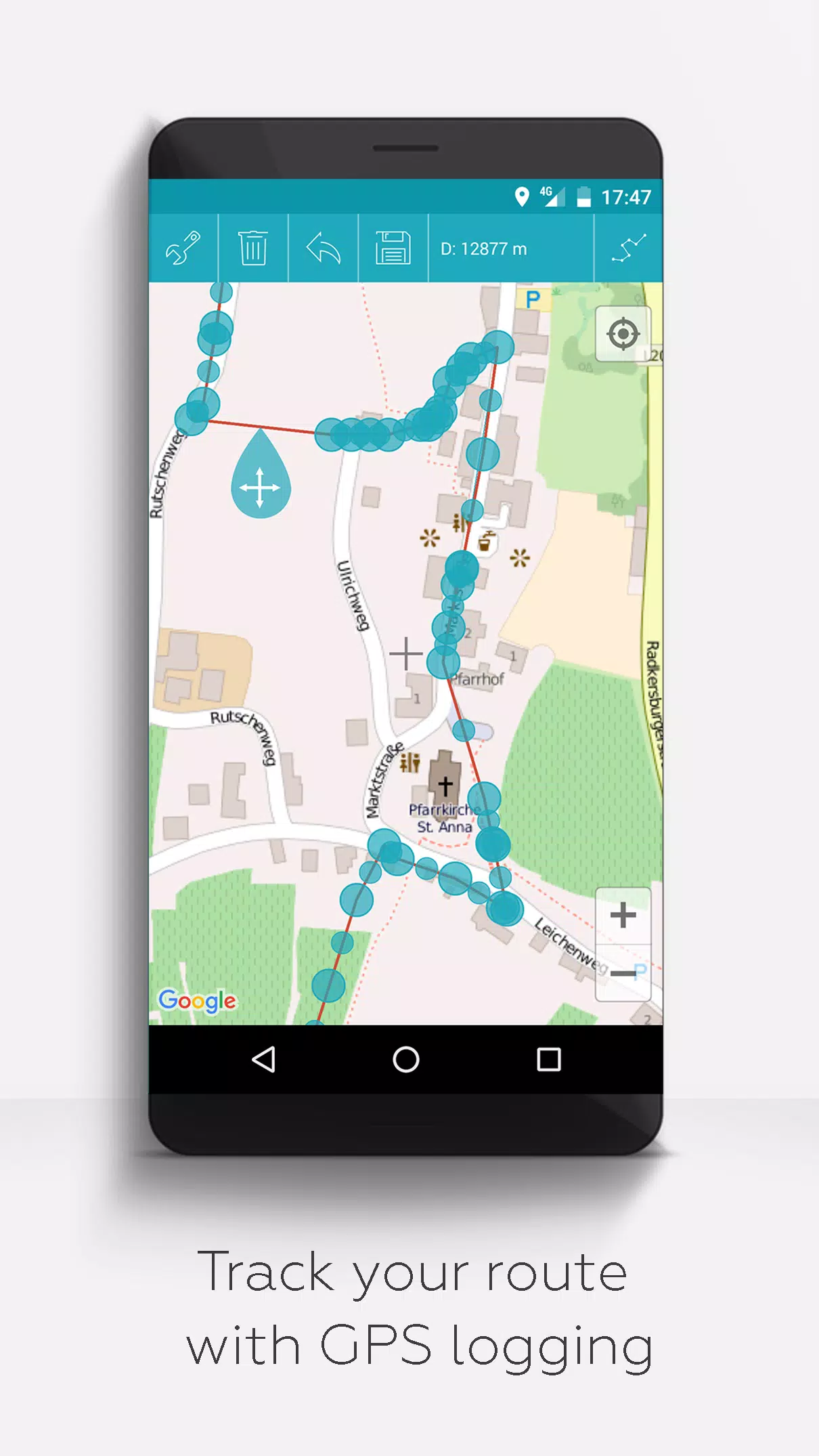
- GPS Track Recording: Record your GPS tracks.
Unlike other apps, MAPinr respects your privacy and does not engage in data mining or selling. Your donations are voluntary contributions that help support our non-profit mission.
Screenshot
Reviews
Post Comments
Latest Articles

Valve Developer Claims SteamOS Not Aimed at Killing Windows
Valve developer Pierre-Loup Griffais recently sat down for an insightful interview, where he clarified that SteamOS is not intended to be a Windows killer. Dive deeper into the reasons behind Valve's stance and how it relates to their competition with Microsoft.Valve Dev Shares Insights on SteamOS a

Top 10 Shark Movies Ever Ranked
My earliest fears were rooted in the mysterious depths of bodies of water, where the calm surface might conceal a lurking people-eating shark. This paranoia was only amplified by shark movies that constantly reminded me, as a child, that nature's predators could strike at any moment.While the premis
How to Obtain Deer Skin in Kingdom Come: Deliverance 2
In *Kingdom Come: Deliverance 2*, acquiring Deer Skin can be crucial for various in-game crafting needs. Whether you're looking to buy, steal, or craft it yourself, here's a detailed guide on how to get Deer Skin.
Where to Get Deer Skin in Kingdom Come: Deliverance 2
Deer Skin, as you might expect,
Horse Class Tier List: Ultimate Dead Rails Rankings
If you're eager to explore the vast world of Dead Sails and achieve impressive distances without facing death too often, choosing the right class is crucial. To save you from endless trial-and-error, I've crafted the ultimate Dead Rails class tier list for you. Let's dive in and see which classes wi

"Battlefield Waltz: Release Date and Time Announced"
As of now, there has been no official announcement regarding Battlefield Waltz being available on Xbox Game Pass. Fans eagerly awaiting this title will need to keep an eye on future updates from the developers or Xbox for any news on its inclusion in the Game Pass library.
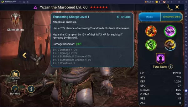
Building Yuzan the Marooned in RAID: Shadow Legends: A Guide
As one of the exciting new champions introduced in April 2025, Yuzan the Marooned is far from being a benchwarmer in your roster. This Epic Void champion from the Skinwalkers faction brings a versatile kit that seamlessly blends healing, buff control, and team protection, making him a valuable asset
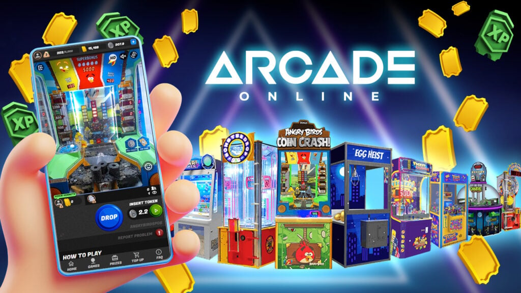
Apps like MAPinr - KML/KMZ/OFFLINE/GIS


Hawaiian Airlines
Travel & Local丨79.90M


STARNow
Travel & Local丨79.2 MB

Alhambra
Travel & Local丨35.2 MB
Yellow Taxi Trnava
Travel & Local丨6.7 MB
Latest Apps


Mini Camera
Photography丨4.6 MB


Befehle für Home
Lifestyle丨8.60M

Hawaiian Airlines
Travel & Local丨79.90M
Trending Apps
MORE +


Top News
MORE +

01
11-14
Dead by Daylight is Officially Adding Lara Croft
Lara Croft is officially coming to Dead by Daylight, Behaviour Interactive has announced. It had long been speculated that Tomb Raider's protagonist would be joining Dead by Daylight's Survivor roster soon, but Behaviour has now put the rumors to rest. Just over a month after the release of
02
12-25
Vienna Opera Delight: Reverse 1.99 Update
Reverse: 1999 Version 1.7 Update: A Viennese Adventure Awaits!
Bluepoch Games' Reverse: 1999 is taking players on a trip back in time with its latest update, Version 1.7, launching players into the captivating world of early 20th-century Vienna in the new "E Lucevan Le Stelle" event. This update del
03
12-11
Disney Mirrorverse Ends Service This Year
Disney Mirrorverse, the mobile game that brought together an epic mashup of Disney and Pixar characters in a brand-new universe, has announced its EOS. Kabam, the company behind the game, just announced that they’ll be pulling the plug on December 16th, 2024.As of today, the game has already been pu
04
12-11
Pokémon GO Celebrates 8 Years with Exciting Raids and Bonuses!
Pokémon GO is celebrating its 8th anniversary with a week-long extravaganza! The festivities begin Friday, June 28th, at 10:00 a.m. and conclude Wednesday, July 3rd, at 8:00 p.m. Get ready for exciting new Pokémon debuts, boosted event bonuses, and enhanced raid and trading opportunities.
Here's a
05
02-02
Stalker 2: 2025 Roadmap Unveiled
With the new year just around the corner, GSC Game World has shared its plans and promises for 2025, offering a glimpse into the future of the S.T.A.L.K.E.R. franchise.
The team continues its dedication to refining S.T.A.L.K.E.R. 2, recently releasing a significant patch (1.1) addressing over 1,800
Topics
More +